Description
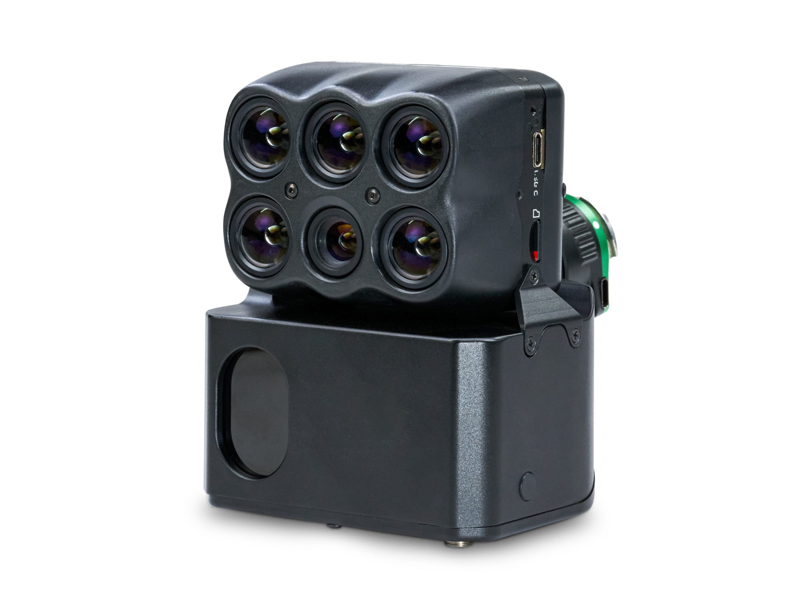
Unleash unparalleled agricultural intelligence and revolutionize your large-scale crop management with the Sentera Direct Georeferencing System (DGR) with 6X/6XT Sensor for DJI M300/M350 (SKU 21246-01) – a game-changing solution that integrates tactical-grade IMU and dual RTK GPS with your DJI Matrice 300/350 drone, paired with science-grade 6X Multispectral and 6X Thermal sensors to deliver radiometrically accurate imagery, empowering professionals, non-profit organizations, and community leaders to make faster, more precise critical decisions and foster thriving, well-managed communities!
Command Your Data: The Ultimate System for Uncompromising Geospatial Accuracy and Efficiency
Are you an agronomist, a crop consultant, a grower, a non-profit organization focused on sustainable agriculture or environmental monitoring, a university or school with advanced geospatial research programs, a religious establishment managing extensive properties, a community center involved in land planning, a park manager, or an apartment complex/Homeowners Association overseeing vast grounds? Imagine transforming your DJI M300/M350 drone into a hyper-accurate data collection powerhouse, drastically reducing project time by nearly 90%, and achieving absolute location certainty with science-grade multispectral and thermal imagery. The Sentera Direct Georeferencing (DGR) System, paired with the groundbreaking 6X Multispectral and 6X Thermal sensors, is meticulously designed to do just that. It integrates tactical-grade inertial measurements (IMU) and dual RTK GPS functionality directly with your drone, fundamentally changing how you capture, process, and analyze aerial data for maximum efficiency and precision.
Benefits That Drive Unprecedented Accuracy and Skyrocket Productivity
This isn't just an accessory; it's a transformative investment in your operational efficiency, data integrity, and ultimate success, offering:
- Achieve Absolute Location Certainty without Ground Control Points: The DGR System provides tactical-grade inertial measurements (IMU) and dual RTK GPS functionality, enabling absolute location certainty. This eliminates the tedious and time-consuming need for defining traditional ground control points, saving you immense setup time and increasing deployment speed for critical missions.
- Drastically Reduce Total Project Time by Nearly 90%: From pre-flight planning to in-the-air image capture to post-processing, the Sentera DGR System increases efficiency and reduces total project time by nearly 90%. This dramatic reduction in workload helps agronomic leaders capture more data, faster, so they can focus on data validation and outcomes, not on tedious processing.
- Accelerate Data Delivery for Faster Decisions: Experience 5x faster data delivery, allowing you to focus your valuable time on analyzing data and measurements to make faster and more precise critical decisions. This rapid turnaround is essential for time-sensitive agricultural interventions, environmental assessments, or dynamic monitoring where immediate insights are crucial.
- Produce Spatially Accurate Maps at the Field's Edge: The Sentera DGR results in spatially accurate maps right at the field’s edge. You no longer need to rely on complex and time-consuming stitching processes to create an orthomosaic, providing immediate, trustworthy data for on-site analysis and action.
- Capture Science-Grade Multispectral and Thermal Imagery: Paired with the Sentera 6X Multispectral and 6X Thermal sensors, the system delivers eight channels of image data with fast-frame rate performance and high radiometric accuracy. This allows for more advanced imagery, providing unparalleled insights into plant health, water stress, thermal signatures, and more, ensuring accurate and reliable data for sophisticated analysis.
The Advantage of Seamless Integration, Robust Precision, and Streamlined Workflow
The Sentera Direct Georeferencing System (DGR) with 6X/6XT Sensor stands out with its intelligent design and unwavering commitment to operational excellence:
- Quick and Easy Integration: The DGR System can be quickly connected to the DJI M300/M350 Drone in just a few steps, ensuring minimal downtime and rapid readiness for flight, making it a truly plug-and-play solution for advanced mapping.
- Optimized for DJI M300/M350 Platform: By leveraging the robust and reliable DJI M300/M350 platform, the DGR System seamlessly integrates with a widely adopted and trusted drone, enhancing its capabilities without requiring a completely new fleet.
- Enhanced Radiometric Accuracy: When paired with radiometric calibration tools, like Sentera’s Calibrated Reflectance Panel and Light Sensor, the system accounts for lighting variations, meaning you get accurate and reliable imagery regardless of changing environmental conditions, crucial for consistent data comparison over time.
- Revolutionary Workflow Efficiency: From pre-flight setup to post-processing, the DGR system fundamentally transforms your workflow, cutting down tedious steps and accelerating data delivery, ultimately saving valuable time and resources for your team.
- Advanced Imaging Capabilities: The 6X/6XT sensors provide more advanced imagery than standard cameras, enabling deeper analysis for a wide array of applications, from agricultural research to infrastructure inspection and environmental monitoring.
Key Features for Superior Aerial Geospatial Data Collection
- System Type: Direct Georeferencing System (DGR).
- Drone Compatibility: Specifically designed for DJI M300/M350 series drones.
- Core Technology: Integrates tactical-grade inertial measurements (IMU) and dual RTK GPS functionality.
- Sensor Included: Sentera 6X Multispectral and 6X Thermal sensors (eight channels of image data).
-
Efficiency Gains:
- Increases efficiency and reduces total project time by nearly 90%.
- Requires 50% less image overlap.
- Captures 9x fewer images.
- Reduces flight time from 45 minutes to less than 20 minutes for typical missions.
- Provides 5x faster data delivery.
- Location Accuracy: Results in absolute location certainty; outputs spatially accurate maps right at the field’s edge (no stitching required for orthomosaic).
- Imagery Quality (6X/6XT): Fast-frame rate performance, high radiometric accuracy, advanced imagery capabilities.
- Radiometric Calibration: Pairs with radiometric calibration tools (e.g., Calibrated Reflectance Panel and Light Sensor) for accurate and reliable imagery.
- Warranty: Manufacturer warranty included.
Invest in Unrivaled Geospatial Precision with Absolute Confidence
Your investment in the Sentera Direct Georeferencing System (DGR) with 6X/6XT Sensor is fully protected by a comprehensive manufacturer warranty, providing you with complete peace of mind. At The Advantage Empire, we believe in creating spaces that grow a sense of community, and with this revolutionary system, you're not just acquiring technology; you're gaining the power to map, analyze, and manage vast areas with unprecedented accuracy and speed, delivering truly transformative results that make lives better. Equip your DJI M300/M350 with the ultimate precision mapping solution. Contact us today to unlock the exhilarating potential of the Sentera DGR System with 6X/6XT Sensor and redefine what's possible in aerial data collection!
Payment & Security
Your payment information is processed securely. We do not store credit card details nor have access to your credit card information.

